PROFILE
- Area: 3850 Sq. Kms
- Forest Area: 59.42%
- Blocks: 7 blocks, which covers 7 Tahasils,
- GPs: 149
- Villages: 1612
- Household: 0.66 lakh ST households (51.13% of total household).
- Population: 5.78 lakhs out of which 3.14 lakh (54.29 %) are ST Population.
ITDA and Micro Projects
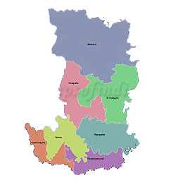
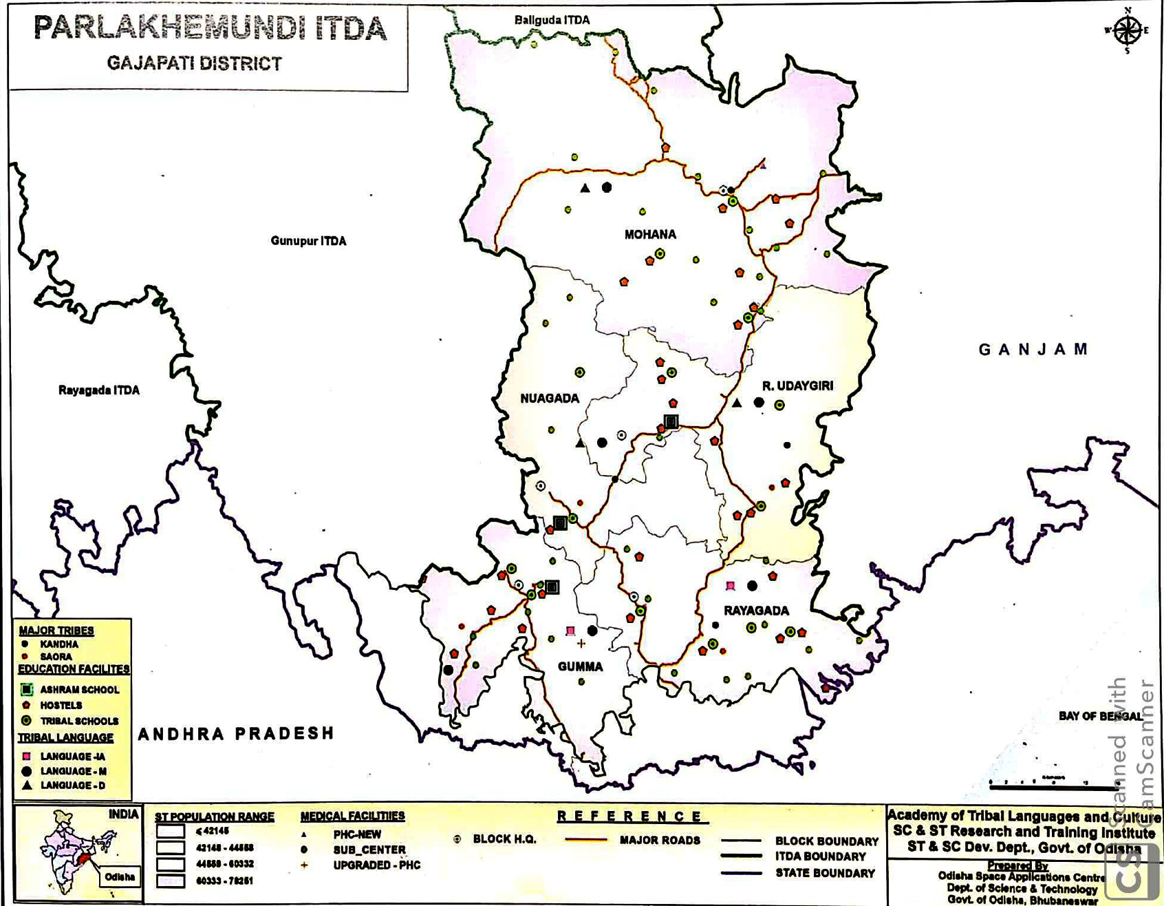
ITDA Paralakhemundi
Paralakhemundi ITDP was established in the year 1974-75 under TSP Guidelines which was registered as ITDA in the year 1979 under the Societies Registration Act, 1860 bearing Registration No 15998/832 of 1979-80. The Jurisdiction of the ITDA Paralakhemundi comprises of one revenue Sub-Division and 5 blocks (Gumma, Rayagada, Nuagada, R. Udaygiri and Mohana), 96 GPs and 1305 inhabited villages and 75 un-inhabited villages. It’s boundary spreads over Ganjam district in the East, Rayagada district in the West, Kondhamal district in the North and Andhra Pradesh in the South. The ITDA is situated 18052’N to 190 38’N Latitude and 830.5’E to 840.25’ Longitude. The geographical division of Paralakhemundi consists Eastern Ghat, North Western plateaus and Southern plateau. Paralakhemundi area has long historic past. Mahendragiri Mountain, Gandahati & Gudguda water falls are important tourist places of Paralakhemundi ITDA area. The ITDA area is crisscrossed by Mahendratanaya river and Radanadi in Mohana Block.
The total geographical area of the ITDA area is 3574.40 sq.km. The total forest area of the ITDA is about 672.47sq.kms. The atmospheric temperature varies between 16 to 48 celcius. The normal annual rainfall is recorded at 1324.86 mm. The soil type of the area is Clay loam, Sandy loam & Red soil. The major crops grown in the ITDA area are paddy, ragi, maize, black gram & horse gram etc.
As per 2011 Census, the total household of the ITDA area is 86135 and total population is 402803 (Male-196404 & Female-206399) out of which ST population is 282612 (Male-136507 & Female-146105). The average household size of Paralakhemundi ITDA area is around 5. The Growth rate of the total population of the area (2001-2011) is 16.20% out of which ST growth rate is (18.91%). As per 2011 census the total sex ratio is 1051 females per 1000 males where as in case of ST it is 1070. The total literacy rate (2011 Census) is 50.42% whereas ST literacy rate is 43.81%. Saora, Bathudi, Bhuiyan, Juang, Gond, Kol, Santal, Sounti & Munda are the major tribal communities living in the project area.
Micro Project: Saora Development Agency Chandragiri
Saora Development Agency, Chandragiri, was established in the year 1978-79 and registered on 1.04.78 under the Society Registration Act, 1960. At present it is functioning in its own Building at Chandragiri. It is spread over 10 GPs in Mohana Block of Gajapati District. The total geographical area of the project is 11.59 sq.kms. Almost three seasons such as cold to very cold in winter, moderate rainy seasons and mild summer seasons are experienced in the area throughout the year. On an average the rainfall of this locality varies from 55” to 60” with about 95 rainy days in a year. The type of soil found in the area is Red Lateritic Group soil.
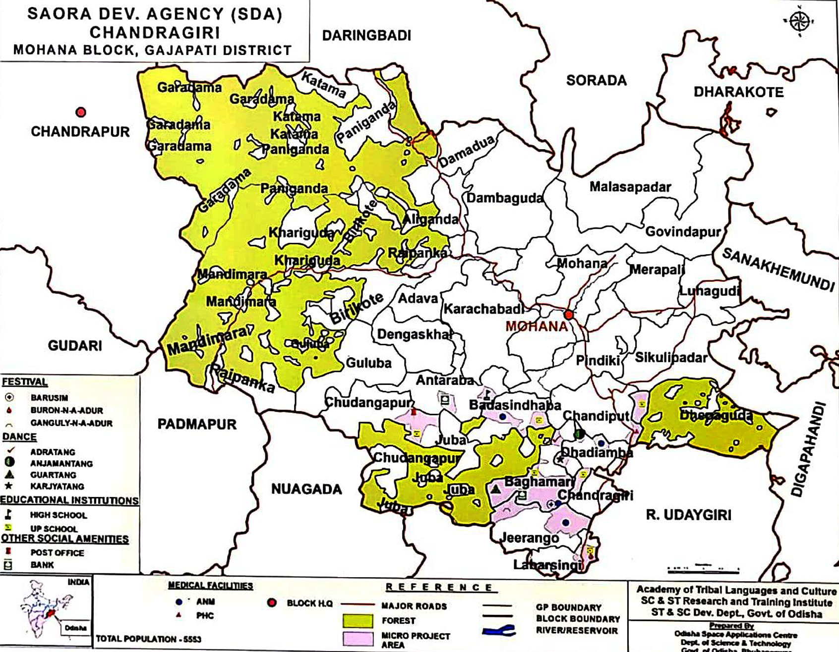
SDA, Chandragiri covers 1263 Saora Households in 32 villages with a total population of 6012 (2998 male & 3014 female). The growth rate is (from 2010-15) as per the base line data available with SCSTRTI is 2.18% and the sex ratio is 1005 per 1000 male. The density of population of the area is 518 per sq.km and the average household size is about 5. The total literacy rate of the Saora is 52.08%. The literacy rate for male is 54.14% and the female literacy rate is 50.03%. They basically depend on shifting and terrace cultivation and depend mainly on collection of minor forest produce for their survival. They are having scattered housing Pattern. They observe Barusini, Buron-a-Adur, Ganguly-na-Adur as their main festivals. Their major dance forms are Guartang, Karjyatang, Adratang and Anjimanatang Dance.
Micro Project: Lanjia Saora Development Agency Seranga
Lanjia Saora Development Agency (LSDA), Serango was established on 21st March, 1979 during Plan holiday (1979-80) and registered under Society registration act 1860 and its head quarters is located at Serango of Gajapati district. It is located 20 kms away from Gumma Block of Gajapati District. Presently it is functioning in its own Building at Serango. It is spread over 3 GPs in Gumma Blocks of Gajapati District. It comes under the jurisdiction of Parlakhemundi ITDA of Gajapati District. The Lanjia Saora Development Agency is lying about 3,000 feet above the sea level. The total geographical area of the project is 30 sq.kms. As such it has undulating terrain with rolling hills, valleys, perennial streams and patches of forests here and there. The project area is ruggedly mountainous so the area experiences a moderate climate, with a short and mild summer, moderate monsoon and a long winter. The average annual rain fall is 1271 mm covering 90 rainy days. The type of soil found in the area is Red Lateritic Soil Group.
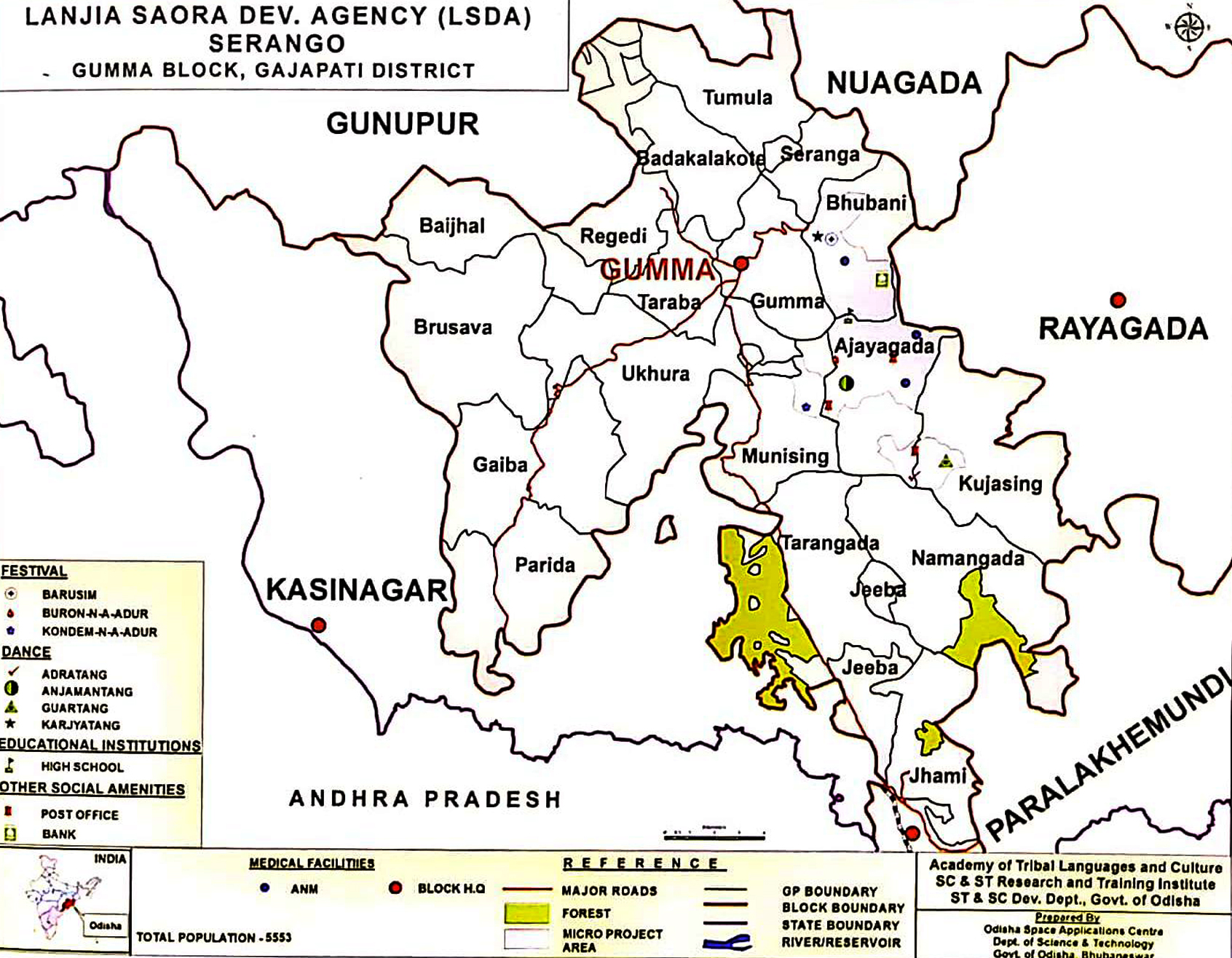
LSDA, Serango covers 1494 Households spread over 21 villages with a total population of 6180 (3068 male & 3112 female). Their growth rate (from 2010-15) is 11.31% and the sex ratio is1014 per 1000 male. The density of population of the area is 206 per sq.km and the average household size is about 4. The total literacy rate of the Lanjia Saora is 35.57%. The literacy rate for male is 37.71% and the female literacy rate is 33.45%. Sora, a Munda Language is their mother tongue. They basically depend on shifting cultivation, settled cultivation, agricultural labour, hunting, and fishing for their survival. They are having scattered settlement pattern. They observe Barusim, Buron-n-a-Adur, Kondem-n-a-Adur as annual festivals. Their major Dance forms are Guartang, Karjyatang, Adratang and Anjamantang.
Demography and Development Indicators
Demography
An overview of the demography of the tribals as a whole in the district of Gajapati shows that as per 2011 Census, the district has 3,13,714 tribal population out of which 1,61812 are female & 1,51,902 are male. This shows that the sex ratio favour the females in the district which is 1065 female per 1000 male.
- Total population: 577817 (Male-282882 & Female-294935)
- ST population: 313714 (Male-151902 & Female-161812)
- Child population (0-6) : All-86984 & ST-54474
- Sex Ratio: All-1043 & ST-1065
- Child Sex Ratio: All-967 & ST-981
- Growth Rate: ALL-11.37 & ST-19.00
- Literacy Rate: All-53.49 & ST-43.66
- Female Literacy Rate: All-43.18 & ST-32.83
- Gender Gap in Literacy: All-21.21 & ST-22.57
- Worker (in lakh): All-2.93 & ST-1.69
- WPR: All-50.87 & ST-54.00
Download: Communitywise & Sector wise Population Scheduled Tribe
- Literacy Rate (Census-2011)
| Category | Total | Male | Female |
|
All |
53.49 |
64.38 |
43.18 |
|
Scheduled Tribe |
43.66 |
55.39 |
32.83 |
- Drop Out Rate (2016-17)
|
Category |
Primary |
Upper Primary |
Elementary |
|
All |
9.19 |
7.71 |
8.45 |
|
ST |
10.57 |
9.38 |
9.98 |
|
Girls |
9.82 |
8.32 |
9.07 |
- SSD Department Schools
|
Category |
Number |
|
High School |
15 |
|
Ashram School |
33 |
|
Educational Complex |
2 |
|
Sevashram (Res) |
19 |
|
Ekalavya Model Residential School (EMRS) |
1 |
|
Hostel |
303 |
Development Indicators
- Human Development Index (2001) : 431 (rank 28)
- Gender Development Index (2001) : 401 (rank 27)
- Infrastructure Development Index (2001) : 45 (Rank 19)
- Gross District Domestic Products (At 2004-05 Price) : 126089 For 2009-10
- Dependency Ratio : 73:1
- Female Literacy Rate : 83%(2011)
- Gross Enrollment Ratio : 44
- Dropout Rate : 19(Primary)
- IMR (As per Annual Health Survey 2012-13): 56
- MMR (As per Annual Health Survey 2012-13): 19
- CBR (As per Annual Health Survey 2012-13): 9
- CDR (As per Annual Health Survey 2012-13): 6
- Institutional Delivery (As per Annual Health Survey 2012-13) : 1
- Full Immunisation (Odisha HMIS Analysis Report 2013): 88
- Nutrition Status (NFHS -4, 2015-16)
- Height-for-age (Under 5 year) : 5
- Weight-for-height-(Under 5 year) : 4
- Weight-for-age- (Under 5 year) : 1
- Percentage of Irrigated Land : 35%
- Average Land Holding : 41 hect
- Percentage of children having any anaemia age(6-59) (<11.0 g/dl)-: 9(NFHS 15-16)
- Percentage of women having any anaemia age(15-49) (<12.0 g/dl)1-: 5(NFHS 15-16)
- Women with BMI <18.5 (total thin)- : 1(NFHS 15-16)
- Women with BMI ≥25.0 (overweight or obese)- : 2(NFHS 15-16)
Districtwise Targets and Achievements of SDC
2018-19
|
Indicator |
Target |
|
Artisan Cards |
3329 |
|
Bilingual Dictionary |
1 |
|
Block Level Cultural Festival |
7 |
|
Block Level Sports |
7 |
|
Dance Costumes |
16 |
|
District Level Cultural Festival |
1 |
|
District Level Sports |
1 |
|
Exposure Visits |
861 |
|
Musical Instrument |
149 |
|
Sacred Groves |
306 |
|
Skill Dev Training |
331 |
|
Sports Kit |
149 |
|
State Level Sports |
1 |
|
Tribal Culture Clubs |
149 |
|
Tribal Museum |
1 |
|
Trilingual Proficiency Module |
1 |
|
Weekly Haat |
26 |
Office Bearers
-
Executive Committee
Executive committee for district:
No.
DESIGNATION
OFFICE BEARERS
1
Chairperson
District Collector
2
Member
Project Director, DRDA
3
Members
District Level Officers to be copted by the District Collector (District Level Officers should include deputy Director of Agriculture, CDMO, Cl of Schools, DFO, District Culture Officer, District Sports Officer, DWO, Special Officers of Micro Projects if any, DI & PRO)
4
Member
Director, DPMU
5
Member
Project Administrator (s), ITDA (s)
6
Member Secretary
The Project Administrator, ITDA located at the District Headquarter or located nearest to the District Head Quarter in case of the Districts having no Head Quarter ITDA


